Dumai name according to folklore about Putri Tujuh, derived from the word Lubuk and umai (a type of urchins animals) that inhabit the depths. Because often spoken quickly, over time those words fit together to d´umai and subsequently became dumai.
In the era of 1930s, Dumai is a small fishing hamlet consisting of a few houses of fishermen. Japan´s population is growing while bringing the romusha (Japanese colonial era forced laborers) from Java. As times change, a change in the status of Dumai as follows:
Years 1945 - 1959, Dumai status listed as villages.
Years 1959 - 1963, Dumai entered in the District Rupat.
Years 1963 - 1964, Dumai split from District Rupat and changed its status Kawedanan.
Based on the PP # 8 of 1979 dated 11 April 1979, changed its status to Dumai Administrative City (a first administrative city in Sumatra and 11 in Indonesia) under the District Level (Dati) II Bengkalis.
Based on Law No.16 of 1999 dated 20 April 1999 (Statute Book of 1999 No. 50, Supplement to Statute Book No. 3829), Dumai municipality changed its status to become the Municipality Dati. II Dumai. As the political developments in Indonesia, based on Law no. 22 In 1999 the municipality changed to Dumai Dumai. The term of office of the first Mayor of Dumai dated 27 April 1999 that made the April 27 anniversary of Dumai.
Philosophical basis for your upgrade status in the management area of ​​Dumai administration is to pemperpendek range control, accelerate and enlarge the role of the level of service the community in governance, management and community development, in addition to capturing the economic development opportunities.
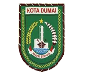
SYMBOL MEANING
Shield / protective shield Containing meaning as symbolized by the five corners of Pancasila. All parts of the shield moss green base color that symbolizes fertility and prosperity.
The words "CITY DUMAI" Shows the status of the area, red with white base.
Numbering 27 Braided rope braid that shows 27 as the anniversary date of Dumai, brown.
Oil Tank Tower & Tower storey 4 shows in 4 days so Dumai, oil tank storey 3 shows the 3 districts at the beginning of the town of Dumai, green and white.
Chain Numbering 99 symbolizes the founding of the City of Dumai and symbolizes a sense of unity and togetherness attitude heterogeneous society, yellow gold.
Star symbolizes the religious community, golden yellow, lies between the end of the rice and cotton.
Rice & Cotton symbolizes prosperity Dumai, rice yellow gold and white cotton.
Two Great boat with a crane symbolizes Dumai port ocean, city transit and the port city of exports and imports, is brown with a white stripe.
Tidal waves symbolize Numbering 3 3 components, namely the construction of the implementation, monitoring and enforcement, in blue and white.
Red and White ribbon with the words "STATE Sorcerer" symbolizes the fighting spirit of the people´s sovereignty and unflagging Dumai, the words "STATE Sorcerer" meaningful expression of gratitude for the success and struggles of Dumai society that is committed to advancing and developing regions in red.
GEOGRAPHIC REGION
Dumai city is one city in the province of Riau, with the name of the capital city of Dumai. Dumai city located on the coast of Sumatra island east. Dumai region positioned between 1010.23 "37 ´- 1010.8´ .13 ´east longitude and 10:23´ .23 ´- 10:24´ .23 ´north latitude. Based on this position, Dumai time zone is UTC +7. Dumai has an area of ​​1,727,385 km2. The boundaries of the city of Dumai adjacent to the following areas:
Strait is bordered to the north Rupat.
East by Bukit Batu subdistrict, Bengkalis.
The south by the District Saber and Bukit Batu subdistrict, Bengkalis.
West bordering the Tanah Putih district and subdistrict Bangko, Rokan Hilir.
Dumai climate is tropical with two seasons: the rainy season and the season kemaraua. The average air temperature between 21-35 0C and the average rainfall between 100-300 mm.
Dumai mostly consists of plains in the north and the south part is a plateau. Conditions of the majority of the land in the form of peat swamp land with a depth of 0 - 0.5 m. Soil structure is generally composed of a red-yellow podzolic soil from sedimentary rocks, alluvial and gley soil and humus organosol in the form of a swamp or wet soil.
There are 15 rivers in the region of Dumai. These rivers are navigable ship pompong, canoes and boats as far up the river. These rivers are rivers:
1. Buluala (40 Km.)
2. Geniut (12 Km.)
3. Bears head (5 Km.)
4. Kemeh (10 Km.)
5. Able (13 Km.)
6. Merambung (7 Km.)
7. Mosque (29 Km.)
8. Publishers (12 Km.)
9. Pelintung (8.5 Km.)
10. Santaulu (22 Km.)
11. Selinsing (4 Km.)
12. Senepis (35 Km.)
13. Tanjung Leban (3 Km.)
14. In the Gulf (10 Km.)
15. Terrace (10 Km.)
Dumai parts still forested. Many flora and fauna in the forest. The main fauna in the forest Dumai is a Sumatran tiger. The animals are protected in special areas Senepis.
Dumai Regency

